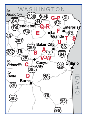
Northeast Oregon
| ID | Parking Area | Activities |
|---|---|---|
| A |
Anthony Lake Area 19 miles west of North Powder. Wallowa-Whitman National Forest, Baker County. |
 Cross-Country Skiing
 Downhill Skiing
 Snowmobiling
 Sledding / Snow Play
|
| B |
Dixie Mountain 6 miles west of ORE 7 on US 26. Malheur National Forest. |
Downhill Skiing
Snowmobiling
|
| C |
Starr Ridge 16 miles south of John Day on US 395. Malheur National Forest. |
Cross-Country Skiing
Snowmobiling
Sledding / Snow Play
|
| D |
Idlewild 15 miles north of Burns on US 395. Malheur National Forest. |
Cross-Country Skiing
Snowmobiling
|
| E |
Four Corners 20 miles east of Ukiah on ORE 244. Umatilla National Forest. |
Snowmobiling
|
| F |
Salt Creek
Summit
28 miles southeast of Joseph on Forest Road 39. Wallowa-Whitman National Forest. |
Cross-Country Skiing
Snowmobiling
Sledding / Snow Play
|
| G |
Tollgate
On ORE 204 at Tollgate. Umatilla National Forest. |
Snowmobiling
|
| H |
Langdon Lake 1 mile east of Tollgate on ORE 204. Umatilla National Forest. |
Snowmobiling
|
| I |
Milepost 20 1 mile east of Tollgate on ORE 204. Umatilla National Forest. |
Snowmobiling
|
| J |
Morning Creek
2 miles east of Tollgate on ORE 204. Umatilla National Forest. |
Snowmobiling
 Dog Sledding
|
| K |
Spout Springs
Ski Area
3.5 miles east of Tollgate on ORE 204. Umatilla National Forest. |
Cross-Country Skiing
Snowmobiling
Downhill Skiing
|
| L |
Milepost 22
On ORE 204 across from Spout Springs Ski Area. Umatilla National Forest. |
Snowmobiling
|
| M |
Woodland
5.5 miles east of Tollgate on ORE 204. Umatilla National Forest. |
Cross-Country Skiing
Snowmobiling
|
| N |
Horseshoe
Prairie Road
7.5 miles east of Tollgate on ORE 204. Umatilla National Forest. |
Cross-Country Skiing
|
| O |
Andies Prairie
8 miles east of Tollgate on ORE 204. Umatilla National Forest. |
Cross-Country Skiing
Snowmobiling
Sledding / Snow Play
|
| P |
Milepost 27
8.5 miles east of Tollgate on ORE 204. Umatilla National Forest. |
Snowmobiling
|
| Q |
Oregon Trail
- Blue Mountain Crossing
1 mile south of I-84, exit 248 on old US 30. Wallowa-Whitman National Forest. |
Cross-Country Skiing
|
| R |
Mt. Emily 6 miles east of Meacham on Forest Service Road 31. Umatilla National Forest. |
Cross-Country Skiing
Snowmobiling
|
| S |
Clear Creek
7 miles north of Halfway on Forest Service Road 66. Wallowa-Whitman National Forest. |
Cross-Country Skiing
Snowmobiling
|
| T |
Ferguson Ridge 10 miles south of Joseph on Tucker Down County Road 633. Wallowa County. |
Cross-Country Skiing
Snowmobiling
|
| U |
Catherine Creek 14 miles south of Union on ORE 203. Wallowa-Whitman National Forest. |
Cross-Country Skiing
Snowmobiling
Sledding / Snow Play
|
| V |
Huddleston 22 miles east of Prairie City on County Road 62. Malheur National Forest. |
Cross-Country Skiing
Snowmobiling
Sledding / Snow Play
|
| W |
Blue Mountain Summit 31 miles east of Prairie City on Forest Road 343. Malheur National Forest |
Snowmobiling
|