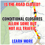
Lake of the Woods / Siskiyou Summit
| ID | Parking Area | Activities |
|---|---|---|
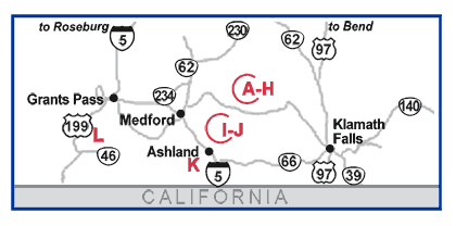
| A |
Summer Homes 28.5 miles east of ORE 62 on ORE 140. Rogue River-Siskiyou National Forest. |
 Cross-Country Skiing
 Snowmobiling
|
| B |
Fish Lake 30.5 miles east of ORE 62 on ORE 140. Rogue River-Siskiyou National Forest. |
Cross-Country Skiing
Snowmobiling
|
| C |
Lake of the
Woods Summit
32.5 miles east of ORE 62 on ORE 140. Fremont-Winema National Forest. |
Cross-Country Skiing
|
| D |
Ichabod Spring 35.5 miles east of ORE 62 on ORE 140. Fremont-Winema National Forest. |
Cross-Country Skiing
Snowmobiling
|
| E |
Four Mile Lake
Road
36 miles east of ORE 62 on ORE 140. Fremont-Winema National Forest. |
Cross-Country Skiing
Snowmobiling
 Dog Sledding
|
| F |
Rainbow Bay 36.6 miles east of ORE 62 on ORE 140. Fremont-Winema National Forest. |
Cross-Country Skiing
Snowmobiling
|
| G |
Great Meadows 37.5 miles east of ORE 62 on ORE 140. Fremont-Winema National Forest. |
Cross-Country Skiing
Snowmobiling
Dog Sledding
|
| H |
Dead Indian 38 miles east of ORE 62 on ORE 140. Fremont-Winema National Forest. |
Cross-Country Skiing
Snowmobiling
Dog Sledding
|
| I |
Buck Prairie 13 miles east of Ashland on Dead Indian Memorial Road. Jackson County. |
Cross-Country Skiing
Snowmobiling
|
| J |
Big Elk 22 miles east of Ashland on Dead Indian Memorial Road. Jackson County. |
Cross-Country Skiing
Snowmobiling
|
| K |
Mt. Ashland 7 miles west of I-5 at Siskiyou Summit. Rogue River-Siskiyou National Forest. |
 Downhill Skiing
Cross-Country Skiing
Downhill Skiing
Cross-Country Skiing
|
| L |
Page Mountain 10 miles east of US 199 on Happy Camp Road. Rogue River-Siskiyou National Forest. |
Cross-Country Skiing
Snowmobiling
 Sledding / Snow Play
|