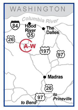
Mt. Hood

| ID | Parking Area | Activities |
|---|---|---|
| A |
Timberline 6 miles north of Government Camp. Mt. Hood National Forest. |
|
| B |
Glacier View 1/2 mile west of Government Camp on US 26. Mt. Hood National Forest. |
|
| C |
Ski Bowl West Across from Government Camp off US 26. Mt. Hood National Forest. |
|
| D |
Ski Bowl East South of Government Camp off US 26. Mt. Hood National Forest. |
|
| E |
Mirror Lake
South of Government Camp off US 26. Mt. Hood National Forest. |
|
| F |
Summit Ski Area
Located at Government Camp on US 26. Mt. Hood National Forest. |
|
| G |
Government
Camp
Government Camp Loop Road. Mt. Hood National Forest. |
|
| H |
Government
Camp Maintenance Station
1/4 mile east of Government Camp on US 26. Mt. Hood National Forest. |
|
| I |
Snow Bunny
Lodge
3 miles east of Government Camp on US 26. Mt. Hood National Forest. |
|
| J |
Trillium Lake 3 miles east of Government Camp on US 26. Mt. Hood National Forest. |
|
| K |
Barlow Pass 2 miles north of US 26 on ORE 35. Mt. Hood National Forest. |
|
| L |
Boy Scout Camp 4 miles north of US 26 on ORE 35. Mt. Hood National Forest. |
|
| M |
White River
West
4 miles north of US 26 on ORE 35. Mt. Hood National Forest. |
|
| N |
White River
East
4 miles north of US 26 on ORE 35. Mt. Hood National Forest. |
|
| O |
Bennett Pass 6 miles north of US 26 on ORE 35. Mt. Hood National Forest. |
|
| P |
Mt. Hood Meadows 38 miles south of Hood River on ORE 35. Mt. Hood National Forest. |
|
| Q |
Hood River
Meadows
37 miles south of Hood River on ORE 35. Mt. Hood National Forest. |
|
| R |
Teacup Lake 36.5 miles south of Hood River on ORE 35. Mt. Hood National Forest. |
|
| S |
Pocket Creek 34.5 miles south of Hood River on ORE 35. Mt. Hood National Forest. |
|
| T |
Little John 31 miles south of Hood River on ORE 35. Mt. Hood National Forest. |
|
| U |
Cooper Spur 30 miles south of Hood River off ORE 35. Mt. Hood National Forest. |
|
| V |
Frog Lake 4.5 miles east of ORE 35 on US 26. Mt. Hood National Forest. |
|
| W |
Skyline Road 10 miles east of ORE 35 on US 26. Mt. Hood National Forest. |
|


