The Volcanic Legacy Scenic Byway
From world-famous Crater Lake National Park to one of America's richest bird refuges, the Volcanic Legacy Scenic Byway owes its dramatic scenery and abundant wildlife to its rich volcanic past.
The Volcanic Legacy Scenic Byway skirts lakes, diverse wetlands, and scenic ranches, all against a stunning backdrop of volcanic landscapes. You'll encounter the ancient natural forces that shaped exquisite mountain lakes and snow-capped peaks all throughout this volcano to volcano driving adventure that stretches from Crater Lake in Oregon to Mount Lassen in Northern California. Along with spectacular scenery, you'll enjoy rich history, charming towns and extraordinary recreational and cultural opportunities.
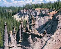 Crater
Lake National Park and its historic Lodge are certainly "high points"
of this Byway. Crater Lake was formed after the collapse of an ancient
volcano, posthumously named Mount Mazama. This volcano's violent eruption,
7,700 years ago, was 42 times as powerful as the 1980 eruption of Mount
St. Helens in Washington State. The basin or caldera was formed after
the top 5,000 feet of the volcano collapsed. Subsequent lava flows sealed
the bottom, allowing the caldera to fill with approximately 4.6 trillion
gallons of water from rainfall and snow melt, to create the seventh deepest
lake in the world.
A little farther along, the Byway passes 90,000 surface-acre Upper Klamath Lake, Oregon's largest lake. Famous for its diverse birdlife and oversized rainbow trout, Upper Klamath Lake is the centerpiece of the Klamath Basin, the largest freshwater ecosystem west of the Great Lakes. The six National Wildlife Refuges scattered across the Basin host over one million birds during peak migration periods, and serve as wintering grounds for as many as 500 bald eagles.
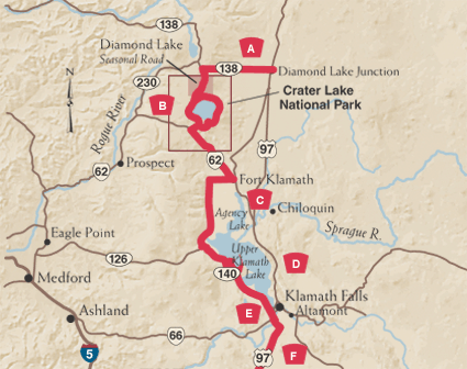
A. Approach to Crater Lake's North Entrance
The Byway begins at Diamond Lake Junction, about halfway between Bend and Klamath Falls on Route 97. Here, Oregon Route 138 gradually climbs to the north entrance of Crater Lake National Park. Because of snow, this entrance is usually only open from June through October; the South entrance, however, is open year-round.
B. The Wonders of Crater Lake
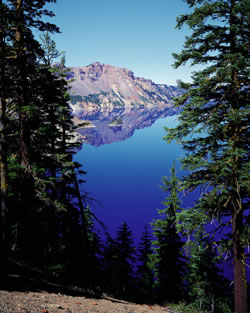 Words can't do justice to your first breathtaking look at Crater Lake,
which was created by the eruption and collapse of Mt. Mazama. From a six-mile
wide, 8,000-foot high caldera, you take in the bluest — and deepest
— lake you've ever seen. Crater Lake National Park is the nation's
fifth oldest national park, dedicated in 1902. Natural wonders abound,
and the 71-room historic Crater Lake Lodge is worthy of its grand surroundings.
The lodge (listed on the National Register of Historic Places) was built
in 1915 to boost the tourist potential of the new park. In the early 1990s
the lodge underwent considerable restoration and renovation.
During summer, visitors can navigate the 33-mile rim drive around the lake, enjoy boat tours on the lake or hike some of the park's various trails, including 8,929-foot Mt. Scott. The winter brings some of the heaviest snowfall in the country, averaging 533 inches per year. Although park facilities mostly close for this snowy season, visitors can view the lake during fair weather, enjoy cross-country skiing, and participate in weekend snowshoe hikes. Crater Lake National Park is home to abundant wildlife, including black bear, elk, pine marten and bald eagles - though these creatures are secretive and not often seen. On a clear day, 9,182-foot Mt. Thielsen - known as the Lightning Rod of the Cascades, for its tendency to attract strikes on its spire-like peak - will be in view to the west.
C. Fort Klamath
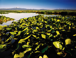 Exiting Crater Lake Park through the south entrance and turning left
on Oregon Route 62, you'll follow Annie Creek through peaceful pastures
to the historic town of Fort Klamath. The Fort the town takes its name
from played an important role in the 1864 Peace Treaty of Council Grove
and in the conduct of the Modoc Indian War of 1872-1873, including its
use as the site for Modoc War trials and executions. The historic site
of the military installation now features a reconstruction of one of the
original buildings and several historical displays. Located in the heart
of the lush Wood River Valley, Fort Klamath today boasts a thriving cattle
industry. The Wood River — a spring creek that bubbles up from the
ground north of town — is highly regarded for its native brown and
rainbow trout.
D. Klamath Lake
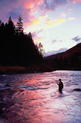 The Byway continues on Weed Road to Sevenmile Road west, then south on
West Side Road. Soon you'll reach the edge of the upper Klamath Wildlife
Refuge and Upper Klamath Lake. Covering 133 square miles, Upper Klamath
Lake is Oregon's largest body of fresh water, filling a basin created
when the earth's crust dropped along fault lines on both sides. The lake
and refuge are situated in the heart of the Pacific Flyway, which attracts
more than 430 species of birds, including sandhill cranes, pelicans and
bald eagles. During peak migration times in the fall, more than a million
birds pass through. Upper Klamath Lake is also renowned by anglers for
its mammoth native rainbow trout, some of which approach 20 pounds. In
the shadow of Mt. McLoughlin, West Side Road connects with Oregon Route
140 along the lake. Howard Bay is a common place to see nesting pelicans,
blue herons, and snow geese. The southern end of the lake is home to bald
eagles all year round.
E. Klamath Falls
The Byway continues south as Oregon 140 meets U.S. Route 97 two miles south of downtown Klamath Falls. Ideally located halfway between San Francisco and Portland, Klamath Falls began to realize its potential when the railroad arrived in 1909, and with the construction of the magnificent White Pelican Hotel. The city's stately new landmark set the stage for a building boom, which turned Klamath Falls into a playground for wealthy San Franciscans. A thriving "entertainment industry" soon sprung to life; in the 30s, brothels and saloons were packed on Friday nights with loggers and ranch hands, and theatres held live performances. Today, the art deco Ross Ragland theatre remains intact. Another architectural tribute to Klamath Falls' past is the Baldwin Hotel, built in 1906, which features period furnishings; the Baldwin is where President Theodore Roosevelt signed the papers creating Crater Lake National Park. Also notable is the Favell Museum, which displays over 100,000 Indian artifacts, works of over 300 major contemporary Western artists, and the largest miniature gun collection in the world.
F. Other Refuges
After passing through cropland along the Klamath River, you'll travel between the Bear Valley National Wildlife Refuge and Lower Klamath National Wildlife Refuge. This segment of the Byway ends on the California border at the Francis S. Landrum Historic Wayside, which commemorates the Applegate Emigrant Trail. If you continue south, you'll reach Lava Beds National Monument.
Crater Lake
Local Native Americans witnessed the collapse of Mount Mazama, and kept the event alive in their legends. One such legend of the Klamath people tells of two Chiefs, Llao of the Below World and Skell of the Above World, pitted in a battle which ended up in the destruction of Llao's home, Mt. Mazama. The mountain's eruption led to the creation of Crater Lake. The Klamaths revered the lake and the surrounding area, shielding it from white explorers until 1853, when three gold prospectors stumbled upon the lake. But gold was more on the minds of settlers at the time and the discovery was soon forgotten. Captain Clarence Dutton, commander of a U.S. Geological Survey party, was the next white man to visit Crater Lake. From the stern of his survey boat the Cleetwood, Dutton's sounded the depths of the astonishingly blue waters with lead pipe and piano wire. His recording of 1,996 feet was amazingly close to sonar readings made in 1959 that established the lake's deepest point at 1,932 feet — which makes Crater Lake the deepest lake in the United States.
