The Hells Canyon Scenic Byway
The Hells Canyon Scenic Byway is a 218-mile loop encircling the Wallowa Mountains, intersecting with Interstate 84 at La Grande and Baker City. Extremes in the land define this Byway and have likewise shaped the region's cultural history. At the eastern edge of the Byway is the Hells Canyon stretch of the Snake River, North America's deepest gorge. It boasts hair-raising rapids, awesome rock formations, and many signs of the indigenous peoples that once called this vast area home.
 At
the core of the Byway are the Wallowa Mountains whose jagged, snowcapped
peaks are reminiscent of the Swiss Alps. Millions of years ago, the Wallowas
formed the coast of present-day Oregon. Flows of plateau basalt, batholiths
of granite, and layers of shale were buckled and folded to form the mountain
range we experience today.
At
the core of the Byway are the Wallowa Mountains whose jagged, snowcapped
peaks are reminiscent of the Swiss Alps. Millions of years ago, the Wallowas
formed the coast of present-day Oregon. Flows of plateau basalt, batholiths
of granite, and layers of shale were buckled and folded to form the mountain
range we experience today.
South and west of the Wallowas, the bountiful Grande Ronde Valley unfolds. Once a spring and summer gathering place for members of the Umatilla, Yakima, Shoshone, Walla Walla, Cayuse and Bannock Nations, the valley is now a rich agricultural center, hosting fields of hay, wheat, grass, mint, and canola as well as cattle, sheep, and horse farms.
 Between Hells Canyon, the Eagle Cap Wilderness area, and the Wallowa-Whitman National Forest, the Byway offers incomparable outdoor recreational opportunities. Numerous campgrounds and trail systems are available. Anglers can fish the region's many rivers or Wallowa Lake. Hunters can pursue deer, elk, bear, cougar or bighorn sheep. Visitors can experience the back-country on a pack trip or rafting adventure. When the snow falls, downhill skiing is available at several area resorts, and abundant open spaces make for a snowmobiling/snowshoeing wonderland. Cultural events and attractions showcasing the region's heritage including rodeos, PowWows, music festivals, craft shows, concerts and other community celebrations can be enjoyed all along the Byway, throughout the year.
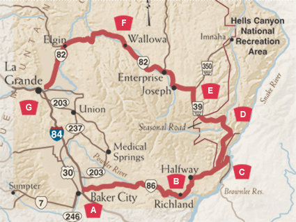
The Hells Canyon Scenic Byway winds through the northeast corner of Oregon, taking in the craggy 8,000 foot depths of Hells Canyon and the 10,000 foot peaks of the Wallowa Mountains. Along the way, you'll encounter exceptionally scenic country and fascinating cultural history in the ancestral homelands of Chief Joseph and the Nez Perce Indians.
A. Baker City
As you travel on Interstate 84, enter the Byway's southern end by taking exit 304 and following the signs to Oregon Highway 86. Start your canyon adventure with a tour of the National Historic District in Baker City, the "Queen City of the Mines." Turn-of-the- century Victorian architecture dominates the commercial and residential buildings of the city's downtown, where many buildings, including the famous Geiser Grand Hotel, have been carefully restored. North of town, take Oregon Route 86 east to the National Historic Oregon Trail Interpretive Center at Flagstaff Hill.
B. The Baker-Copperfield Highway
 Continue east on Oregon Route 86 through sagebrush-covered plateaus,
the fertile farms of Richland, and mining towns like Halfway, Pine and
Copperfield. Early pioneers first traveled portions of this route on their
way to the Willamette Valley in the early 1840s. Gold strikes on the southern
side of the Wallowa Range brought another wave of settlers to the region
in the 1860s. Later settlers were attracted by fertile valleys and abundant
timber; agriculture and forest products are still important industries
throughout northeast Oregon. Today, visitors come to Halfway for a variety
of outdoor activities including backpacking, llama excursions, snowmobiling,
cross-country skiing, fishing and hunting. Many use the town as a point
of departure for Hells Canyon adventures.
Continue east on Oregon Route 86 through sagebrush-covered plateaus,
the fertile farms of Richland, and mining towns like Halfway, Pine and
Copperfield. Early pioneers first traveled portions of this route on their
way to the Willamette Valley in the early 1840s. Gold strikes on the southern
side of the Wallowa Range brought another wave of settlers to the region
in the 1860s. Later settlers were attracted by fertile valleys and abundant
timber; agriculture and forest products are still important industries
throughout northeast Oregon. Today, visitors come to Halfway for a variety
of outdoor activities including backpacking, llama excursions, snowmobiling,
cross-country skiing, fishing and hunting. Many use the town as a point
of departure for Hells Canyon adventures.
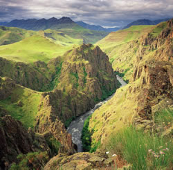
C. Snake River and Hells Canyon
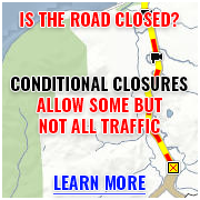
About six miles past the junction of Forest Road 39, you'll discover the mighty Snake River as it approaches the southern end of Hells Canyon, the deepest river-carved gorge in North America. According to Nez Perce folklore, Coyote dug Hells Canyon with a big stick to protect ancestors in Oregon's Blue Mountains from the Seven Devils mountain range across the gorge in what is now Idaho. Geologists believe that Hells Canyon was formed by normal stream erosion as the Snake River cut its way through rocks of a rising mountain range, beginning 6 million years ago. It is still being cut and is probably deeper and more rugged today than at any other time in its history. The 652,488-acre Hells Canyon National Recreation Area, (designated in 1975), encompasses a 71-mile stretch of the Snake River and contains some of the country's most unique scenery, plants, wildlife and geology. Relatively mild winters and abundant deer, elk, and bighorn sheep drew native peoples to the canyon; signs of human habitation date back over 11,000 years. Pictographs and petroglyphs, as well as winter pithouse villages, are scattered along the river, documenting the presence of those early inhabitants. A rafting or jet boat excursion on the Snake provides an excellent way to experience the abundant wildlife and grandeur of the canyon.
D. Hells Canyon Overlook
Return to Forest Road 39 and travel 16 miles to Forest Road 3965. From here, a short drive brings you to breathtaking vistas at Hells Canyon Overlook. The paved overlook, which rests at 5,400 feet, provides outstanding views of McGraw Creek, Hells Canyon, and the Seven Devils Mountains which stand at the Idaho border. The Overlook features interpretive displays about the canyon formation.
E. Wallowa Mountains and Eagle Cap Wilderness
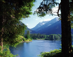 Back on Forest Road 39, you'll head north across the "Wild and Scenic"
Imnaha River and then west toward some impressive views of the majestic
Wallowa Mountains. The Imnaha provides important spawning habitat for
steelhead trout and chinook salmon, and some excellent angling opportunities.
The 387,915 acre Eagle Cap Wilderness offers five campgrounds and ten
trailheads, should you wish to stretch your legs and explore this pristine
wilderness up close and personal. Skirting the northeast foothills of
the Wallowa Range, you'll soon reach Joseph, a quaint recreational hub
and thriving art community. One mile south of town, glacially-formed Wallowa
Lake features a state park with a variety of accommodations including
yurts for rent. A tramway takes you to the summit of Mt. Howard, and there's
superb fishing and hiking for all ages in local streams and the lake.
Geologists have proclaimed the moraines on either side of Wallowa Lake
the most impressive moraines in the world.
Back on Forest Road 39, you'll head north across the "Wild and Scenic"
Imnaha River and then west toward some impressive views of the majestic
Wallowa Mountains. The Imnaha provides important spawning habitat for
steelhead trout and chinook salmon, and some excellent angling opportunities.
The 387,915 acre Eagle Cap Wilderness offers five campgrounds and ten
trailheads, should you wish to stretch your legs and explore this pristine
wilderness up close and personal. Skirting the northeast foothills of
the Wallowa Range, you'll soon reach Joseph, a quaint recreational hub
and thriving art community. One mile south of town, glacially-formed Wallowa
Lake features a state park with a variety of accommodations including
yurts for rent. A tramway takes you to the summit of Mt. Howard, and there's
superb fishing and hiking for all ages in local streams and the lake.
Geologists have proclaimed the moraines on either side of Wallowa Lake
the most impressive moraines in the world.
F. From Enterprise to Elgin
From Joseph, take Oregon Route 82 to nearby Enterprise where the Visitors Center offers a magnificent view of the rugged Wallowa Mountains and presents the scenic, historic and recreational features of the Hells Canyon National Recreation Area and the Wallowa-Whitman National Forest. The largest of the Wallowa Valley communities, Enterprise offers an array of shops and accommodations, as well as back country and river outfitters. You'll continue west through the communities of Lostine and Wallowa, which houses the Nez Perce Interpretive Center. Soon, the Byway enters a canyon and adjoins the beautiful Wallowa River. At the confluence of the Minam and Wallowa Rivers, the highway takes a steep climb up the Minam Grade. This dramatic stretch of road provides a commanding view of the Wild and Scenic Minam River and the surrounding steep ridges. You'll soon reach Elgin, an agricultural and timber town that is home to the roaring Elgin Stampede PRCA Rodeo each July and the elegantly restored Elgin Opera House, built in 1912, which now presents movies, concerts, and live theater.
G. Lovely La Grande
Your mountain adventure ends in the Grande Ronde Valley and La Grande which was established as a rest stop along the historic Oregon Trail. A wide variety of travel services and proximity to varied terrain make La Grande a popular recreation base for cyclists, hikers, hunters, fishermen, and skiers, as well as snowmobile and ATV enthusiasts. The site of Eastern Oregon University, this lovely town offers year-round cultural events. Walking tours highlight the community's historic homes, urban forest, and commercial Historic District.
Other Nearby Attractions
Learn more about northeast Oregon's history by visiting these nearby attractions:
- Ranching and Cowboy History: Cowboys Then & Now Exhibit at the Union County Museum in Union
- Settlement & Early Twentieth Century History: Eastern Oregon Museum in Haine
- Mining: The Sumpter Dredge State Historic Monument and Sumpter Valley Railroad at Sumpter
National Historic Oregon Trail Center
Built and operated by the Bureau of Land Management, the center is a monument to emigrants who journeyed on the Oregon Trail. It offers a number of interactive exhibits and dioramas, seasonal living history performances, and interpretive / educational programs in an indoor theater. The center covers historic themes including exploration, mining, and settlement history. Paved footpaths lead to 150-year-old wheel ruts left by hundreds of pioneer wagons.
A Town Cast in Bronze
Named for young Chief Joseph, this town has earned a national reputation for its bronze foundries and galleries. Some of the nation's most highly acclaimed artists cast their bronzes at one of the four area foundries or show their work in one of the many galleries that line the town's picturesque Main Street. Snuggled at the base of the Wallowas and in close proximity to Wallowa Lake, Joseph is a popular destination for hikers, hunters, and fisherman. It's also home of the Chief Joseph Days Rodeo and the nationally known Fishtrap Writers Conference.
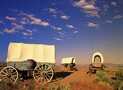
A Pioneer Resting Place
The Powder River and Grande Ronde Valleys were important emigrant stops on the historic Oregon Trail. Beginning in 1843 and continuing for several decades, the lure of abundant, rich farm land, clear water and seemingly endless forests brought over 350,000 Americans westward to the famed Oregon Country. Usually leaving the mid-west in the spring, they walked or rode horseback over 2,000 miles of wilderness, carrying their possessions in covered wagons. The lush Grande Ronde and Powder River Valleys provided welcome respite after months of hot, dusty travel.
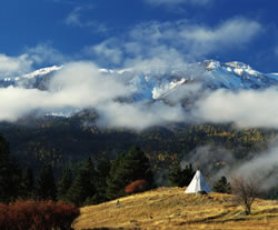
Chief Joseph and the Nez Perce
The picturesque Wallowa Valley was the beloved home of the Nez Perce Indians. By winter of 1877, settlement conflicts drove Young Chief Joseph to make a tragic attempt to reach Canada with a group of 250 men, women, and children. They struggled to within 24 miles of safety before being captured in Montana and sent to reservations. This area remains a significant religious and cultural center for the Nez Perce, Umatilla, and Cayuse Indians. The word Wallowa is derived from the Nez Perce name for the tripod that supported the fishing nets used in area rivers. The Wallowa band of the Nez Perce gathers in the Valley each July for TamKaLiks, an annual Friendship Feast and Powwow.