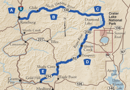
The Rogue Umpqua Scenic Byway
Two of Oregon's most beautiful and renowned rivers book end this breathtaking tour through the thickly forested southern Cascades.
More commonly known as the "highway of waterfalls," the Rogue-Umpqua
Scenic Byway ascends from I-5 into the southern Cascades, tracking two
of Oregon's most storied rivers. The first leg of the trip follows the
North Umpqua east from Roseburg. A river of unparalleled beauty, the North
Umpqua is revered worldwide for its steelhead fishing.
 After passing more than a half dozen waterfalls, the Byway reaches sparkling
Diamond Lake, at the base of Mt. Thielsen (which is a short drive from
Crater Lake). The byway then bends south, and soon follows the "Wild
and Scenic" Rogue River. With abundant hiking, fishing, and camping
opportunities, visitors will understand why this Byway is one of the state's
best-loved areas.
After passing more than a half dozen waterfalls, the Byway reaches sparkling
Diamond Lake, at the base of Mt. Thielsen (which is a short drive from
Crater Lake). The byway then bends south, and soon follows the "Wild
and Scenic" Rogue River. With abundant hiking, fishing, and camping
opportunities, visitors will understand why this Byway is one of the state's
best-loved areas.
A. Roseburg
Your trip begins in Roseburg, a town built up by the lumber industry, and now a popular recreational center. Covered bridges, mid-1800 restored homes and the nationally acclaimed Douglas County Museum of History and Natural History give Roseburg historic appeal. If time permits, tour some of the region's eight wineries, which produce chardonnay, pinot noir, gewürztraminer, reisling, zinfandel and cabernet sauvignon varietals. From Roseburg, the Byway heads east on Oregon Route 138 through scenic oak-dotted hills.
B. Up the North Umpqua
 As you head east, the forest will thicken, the air will cool, and you'll
soon hear the rush of water. Check out the Colliding Rivers in the community
of Glide, where the North Umpqua and Little River converge in a fury of
white water; it's one of the few places in the world where rivers meet
head-on. From here, the Byway parallels the "Wild and Scenic"
North Umpqua, considered by many to be one of the most beautiful rivers
in America. Driving along the North Umpqua, you'll pass anglers fly fishing
for steelhead or salmon, white water rafters, kayakers, and numerous pulloffs
for taking in the scenery or taking a hike. If you're inclined to stretch
your legs, the well-maintained North Umpqua Trail follows the east bank
of the river for 79 miles. Divided into eleven segments from over 3 to
just under 16 miles in length, the trail leads high into the Cascade Mountain
Range, and connects with the Pacific Crest National Scenic Trail. Near
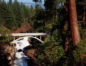
Steamboat, check out the Mott Bridge, a recognized Oregon Historic Civil
Engineering Landmark. Constructed by the Civilian Conservation Corp in
1935-36, the bridge is the only surviving example of three such structures
built at that time in the Pacific Northwest.
As you head east, the forest will thicken, the air will cool, and you'll
soon hear the rush of water. Check out the Colliding Rivers in the community
of Glide, where the North Umpqua and Little River converge in a fury of
white water; it's one of the few places in the world where rivers meet
head-on. From here, the Byway parallels the "Wild and Scenic"
North Umpqua, considered by many to be one of the most beautiful rivers
in America. Driving along the North Umpqua, you'll pass anglers fly fishing
for steelhead or salmon, white water rafters, kayakers, and numerous pulloffs
for taking in the scenery or taking a hike. If you're inclined to stretch
your legs, the well-maintained North Umpqua Trail follows the east bank
of the river for 79 miles. Divided into eleven segments from over 3 to
just under 16 miles in length, the trail leads high into the Cascade Mountain
Range, and connects with the Pacific Crest National Scenic Trail. Near
Steamboat, check out the Mott Bridge, a recognized Oregon Historic Civil
Engineering Landmark. Constructed by the Civilian Conservation Corp in
1935-36, the bridge is the only surviving example of three such structures
built at that time in the Pacific Northwest.
This shady route through the Umpqua National Forest passes Swiftwater Park, Toketee Reservoir, and several dramatic formations, including Eagle Rock and Old Man Rock. Be sure to visit at least one of the many waterfalls which are accessible by well-marked and well-maintained trails. Have your camera ready; the fall colors along this stretch of road can be stunning.
C. Sparkling Diamond Lake
 Once it leaves the North Umpqua, Route 138 turns south to circle Diamond Lake,
a scenic gem nestled between Mt. Bailey and the lightning-rod spire of
Mt. Thielsen. Here you'll find complete resort facilities, including lodging,
a marina and horse stables. In summer and fall, you can fish for stocked
rainbow trout or bike around the lake on a paved path. In winter the path
is transformed into a groomed cross-country ski trail, and the lake into
a giant ice rink. Mt. Bailey offers outstanding snowcat skiing.
Once it leaves the North Umpqua, Route 138 turns south to circle Diamond Lake,
a scenic gem nestled between Mt. Bailey and the lightning-rod spire of
Mt. Thielsen. Here you'll find complete resort facilities, including lodging,
a marina and horse stables. In summer and fall, you can fish for stocked
rainbow trout or bike around the lake on a paved path. In winter the path
is transformed into a groomed cross-country ski trail, and the lake into
a giant ice rink. Mt. Bailey offers outstanding snowcat skiing.
At the southern end of Diamond Lake, Oregon Route 138 curves east toward the north entrance of Crater Lake National Park. The Rogue-Umpqua Scenic Byway heads west to join Oregon Route 230. Here you can enjoy unimpeded views of the peaks and ridges above Crater Lake—the remains of erupted Mt. Mazama—from the Crater Rim Viewpoint.
D. Running down the Rogue
 Coursing through the Rogue River National Forest, Oregon Route 230 merges with
Oregon Route 62 near historic Union Creek, western terminus of the Fort
Klamath military wagon road, which was an important trail for settlers
crossing the Cascades. Union Creek is also the site of a historic resort
built by the Civilian Conservation Corp. The road soon parallels the "Wild
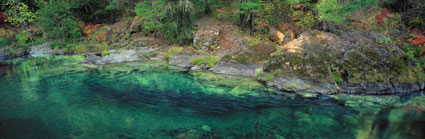
and Scenic" Rogue River. The Rogue, like the North Umpqua, supports
endangered populations of Chinook and Coho salmon, as well as steelhead
and cutthroat trout. The Rogue Gorge and Natural Bridge interpretive sites
offer interesting perspectives of the river as it thunders through deep,
narrow chasms. Under a canopy of conifers between here and Prospect, you'll
find several riverside campgrounds where you can enjoy the sounds of the
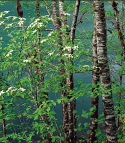
river or hook a few trout. Wildflowers are abundant along the Upper Rogue,
providing a brilliant contrast to the green of the forests. Lost Creel
Lake and Stewart State Park are popular for boating and waterskiing, among
other outdoor activities. A bit farther south, Shady Cove is a popular
point of departure for river rafters and anglers setting out to float
the Rogue.
Coursing through the Rogue River National Forest, Oregon Route 230 merges with
Oregon Route 62 near historic Union Creek, western terminus of the Fort
Klamath military wagon road, which was an important trail for settlers
crossing the Cascades. Union Creek is also the site of a historic resort
built by the Civilian Conservation Corp. The road soon parallels the "Wild
and Scenic" Rogue River. The Rogue, like the North Umpqua, supports
endangered populations of Chinook and Coho salmon, as well as steelhead
and cutthroat trout. The Rogue Gorge and Natural Bridge interpretive sites
offer interesting perspectives of the river as it thunders through deep,
narrow chasms. Under a canopy of conifers between here and Prospect, you'll
find several riverside campgrounds where you can enjoy the sounds of the
river or hook a few trout. Wildflowers are abundant along the Upper Rogue,
providing a brilliant contrast to the green of the forests. Lost Creel
Lake and Stewart State Park are popular for boating and waterskiing, among
other outdoor activities. A bit farther south, Shady Cove is a popular
point of departure for river rafters and anglers setting out to float
the Rogue.
E. Gold Hill and the Rogue Valley
Oregon Route 234 heads west, rejoining the Rogue in the friendly town of Gold Hill, the Byway's southern portal. En route, Table Rocks—flat-topped remnants of lava flows that filled the canyons of the Rogue over seven million years ago—rise dramatically from the Valley with Upper Table Rock soaring 800 feet. From here, the bustling Rogue Valley cities of Medford, Jacksonville, Ashland and Grants Pass are less than an hour away.
Sacred Steelhead Waters
Flyfishers the world over prize the North Umpqua for its run of summer steelhead. Steelhead—ocean-going rainbow trout—are one of the most prized gamefish of the Pacific Northwest, and grow from 8 to 20 pounds. The North Umpqua offers 30 miles of fly fishing-only water, all accessible from the road. Fishing is not easy on the North Umpqua but it is nonetheless a wonderful experience—just ask Jimmy Carter, Tom Brokaw and the many other notables who fish here! Anglers and conservationists have rallied to preserve the North Umpqua's habitat and fishery. If you visit in the late summer or fall, take a small side trip to Big Bend Pool on Steamboat Creek (10 miles from Steamboat Inn) to see one result of their conservation work—an observatory where you can view hundreds of native steelhead.
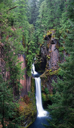
Wonderful Waterfalls
There are fifteen waterfalls along the Rogue-Umpqua Scenic Byway. Photographers and artists from all over the world come to capture these awe-inspiring images. Susan Creek Falls, Toketee Falls and Watson Falls are three favorites. Watson Falls, which tumbles 272 feet, is the third highest waterfall in Oregon. The mist of the falls provides great relief on warm summer days.