The Oregon Outback Scenic Byway
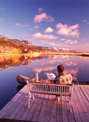
Solitude awaits you on this adventure through Oregon's remote, yet easily accessible high desert. Enjoy the play of light on the rocks and prairie, the smell of sagebrush, and the sounds of silence.
 The Outback Scenic Byway takes you through a slice of the Great Basin Region,
capturing the landscape's rugged diversity, and the independence of the
people who've honed a living from a hard land. Outback is isolated rural
country, and this area of Oregon is that. As you push south along the
Byway, lush green forests in the shadow of the Cascades are replaced by
sagebrush and rock formations. It's an austere landscape at first glance,
but rich in detail upon closer examination. This Byway's lakes are resting
spots for waterfowl on the Pacific Flyway, which provide a visual oasis
amidst this arid country.
The Outback Scenic Byway takes you through a slice of the Great Basin Region,
capturing the landscape's rugged diversity, and the independence of the
people who've honed a living from a hard land. Outback is isolated rural
country, and this area of Oregon is that. As you push south along the
Byway, lush green forests in the shadow of the Cascades are replaced by
sagebrush and rock formations. It's an austere landscape at first glance,
but rich in detail upon closer examination. This Byway's lakes are resting
spots for waterfowl on the Pacific Flyway, which provide a visual oasis
amidst this arid country.
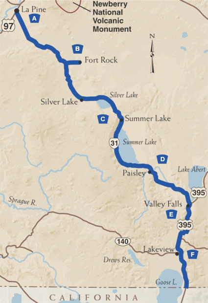
A. Leaving the Cascades
Your "drive-about" through Oregon's Outback begins in the Deschutes National Forest, near the town of La Pine (30 miles south of Bend). From here, head three miles south on U.S. Route 97, then southeast on Oregon Route 31, through stands of lodge pole and ponderosa pine.
B. Fort Rock
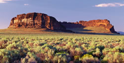 Twenty-seven
miles east of U.S. Route 97, the forest abruptly gives way to vast sagebrush
plains reminiscent of the Australian Outback. You'll soon see Fort Rock,
a mysterious rock formation that emerges abruptly in the east. Fort Rock
is actually a volcanic crater (maar), and rises 325 feet above the high
desert floor; a National Natural Landmark, it gets its name from its four-sided
towering walls. Fort Rock State Park is an easy 7 miles off Oregon Route
31, and offers hiking trails and picnic facilities. En route you'll see
Fort Rock Homestead Village, which preserves several buildings that date
back to the 1800s. Structures were brought in from the surrounding valley
to create this living history museum.
Twenty-seven
miles east of U.S. Route 97, the forest abruptly gives way to vast sagebrush
plains reminiscent of the Australian Outback. You'll soon see Fort Rock,
a mysterious rock formation that emerges abruptly in the east. Fort Rock
is actually a volcanic crater (maar), and rises 325 feet above the high
desert floor; a National Natural Landmark, it gets its name from its four-sided
towering walls. Fort Rock State Park is an easy 7 miles off Oregon Route
31, and offers hiking trails and picnic facilities. En route you'll see
Fort Rock Homestead Village, which preserves several buildings that date
back to the 1800s. Structures were brought in from the surrounding valley
to create this living history museum.
C. Silver and Summer Lakes
Return to Oregon Route 31 and head south toward the community of Silver Lake, named for a dry basin a few miles east that fills approximately every 30 years. From here, the Byway turns south and climbs 4,830-foot Picture Rock Pass, named for ancient Indian petroglyphs that decorate rocks that are within walking distance of the highway.
 From
the pass, you'll see Summer Lake, a long, shallow body of extremely alkaline
water that attracts a tremendous variety of waterfowl. The 18,000-acre
Summer Lake Wildlife Area, with viewing sites, is a breeding and resting
area for nearly 250 species of birds. The marsh-like setting is one of
the most important stops in the region for migrating birds on the Pacific
Flyway. Visitors can view many sensitive, threatened, or endangered species,
such as bald eagles, American peregrine falcons, western snowy plovers,
greater sand hill cranes, and trumpeter swans. Early spring is the best
time to view migrating flocks of waterfowl, and Summer Lake hosts more
than 15,000 bird watchers annually. The small town of Summer Lake offers
a variety of visitor services and a wayside commemorating an 1843 expedition
led by Captain John C. Fremont.
From
the pass, you'll see Summer Lake, a long, shallow body of extremely alkaline
water that attracts a tremendous variety of waterfowl. The 18,000-acre
Summer Lake Wildlife Area, with viewing sites, is a breeding and resting
area for nearly 250 species of birds. The marsh-like setting is one of
the most important stops in the region for migrating birds on the Pacific
Flyway. Visitors can view many sensitive, threatened, or endangered species,
such as bald eagles, American peregrine falcons, western snowy plovers,
greater sand hill cranes, and trumpeter swans. Early spring is the best
time to view migrating flocks of waterfowl, and Summer Lake hosts more
than 15,000 bird watchers annually. The small town of Summer Lake offers
a variety of visitor services and a wayside commemorating an 1843 expedition
led by Captain John C. Fremont.
D. Pull into Paisley
A dozen miles beyond the lake is the town of Paisley, home of the annual Mosquito Festival in July which includes a rodeo, skeet shoot, aviation show and classic car show. Paisley provides all services, hot spring baths, and good access to the Chewaucan River for anglers seeking native redband trout; the river is best accessed from Forest Road 33. Continuing southeast on Route 31, you'll soon pass Lake Abert. The lake's high alkalinity make it ideal habitat for brine shrimp, which provide forage for migrating birds.
E. Abert Rim
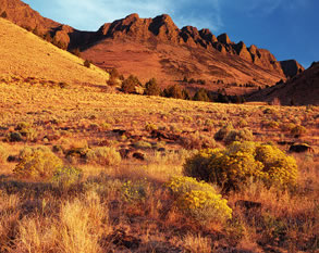 When
you reach Valley Falls, Route 31 joins U.S. Route 395. Here, the horizon
is dominated by Abert Rim, a 30-mile-long fault escarpment one of the
nation's longest and most continuous fault escarpments. This rim rises
more than 2,000 feet above the Byway. The rim's southern section is a
popular launching spot for hang gliders; in fact, the region surrounding
the southern end of the Byway is considered by many to be the hang gliding
capital of the West. Watch for big horn sheep at the base of Abert Rim.
When
you reach Valley Falls, Route 31 joins U.S. Route 395. Here, the horizon
is dominated by Abert Rim, a 30-mile-long fault escarpment one of the
nation's longest and most continuous fault escarpments. This rim rises
more than 2,000 feet above the Byway. The rim's southern section is a
popular launching spot for hang gliders; in fact, the region surrounding
the southern end of the Byway is considered by many to be the hang gliding
capital of the West. Watch for big horn sheep at the base of Abert Rim.
F. Oregon's Tallest Town
Twenty-seven scenic miles later, you'll reach Lakeview, which at 4,800 feet above sea level, is Oregon's "tallest town". Lakeview is home of Oregon's only geyser, situated at a resort a mile north of town. The geyser named Old Perpetual generally shoots 60 feet in the air every 90 seconds; that's much more reliable than Old Faithful in Yellowstone, which erupts every 45 to 90 minutes! While in town, visit the Schminck Memorial Museum, which commemorates pioneer life, and the Lake County Museum. Visit Black Cap, a popular launching spot for hang gliders in the summer, for a spectacular view of the Goose Lake Valley. Skiing is available near Lakeview in the winter. The Outback Scenic Byway ends about 15 miles south of Lakeview at the border town of New Pine Creek. Goose Lake State Recreation Area, a full-service RV park, offers a resting spot before heading on to California.