Over the Rivers & Through the Woods Scenic Byway
This 66-mile route begins in the rich farmland of the Willamette Valley, then winds along rushing streams and through thick forests as it climbs into the Cascades to join the West Cascades and McKenzie Pass-Santiam Scenic Byways.
Along the way you'll pass through some of Oregon's oldest settlements, while experiencing the geographic diversity of five Western Oregon ecosystems. With access to rivers, reservoirs, parks and campgrounds, many trails and snow-play areas, this Byway offers a wide range of recreational activities.
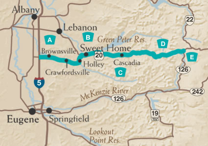
A. East Through the Valley
 Moving
east from Interstate 5, you'll first come to Brownsville, which was settled
in 1846 and is Oregon's third oldest town. Historic structures dot Main
Street, and thanks to preservation efforts, look much the way they did
100 years ago. The Linn County Historical Museum chronicles local history.
During winter months, grass fields around Brownsville host wintering bald
eagles and large flocks of white tundra swans. East from Brownsville,
travelers come upon Crawfordsville, a quiet farming and logging community.
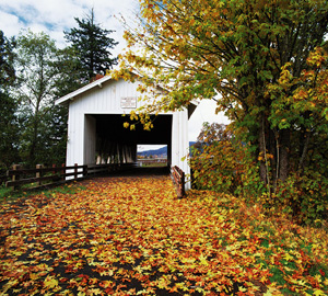
Check out the Crawfordsville Covered Bridge, which spans the Callapooia
River and is adjacent to the Byway. Further east is the tiny logging town
of Holley, which dates back to 1847.
Moving
east from Interstate 5, you'll first come to Brownsville, which was settled
in 1846 and is Oregon's third oldest town. Historic structures dot Main
Street, and thanks to preservation efforts, look much the way they did
100 years ago. The Linn County Historical Museum chronicles local history.
During winter months, grass fields around Brownsville host wintering bald
eagles and large flocks of white tundra swans. East from Brownsville,
travelers come upon Crawfordsville, a quiet farming and logging community.
Check out the Crawfordsville Covered Bridge, which spans the Callapooia
River and is adjacent to the Byway. Further east is the tiny logging town
of Holley, which dates back to 1847.
B. Climbing into the Foothills
 From
Holley, the Byway bends north toward Sweet Home. The towering trees in
the Cascade foothills attracted settlers and sawmills here in the 1850s.
Some of the region's logging history is preserved at the East Linn Museum;
historic Weddle Bridge and the town's colorful murals are also worth a
visit. From Sweet Home, the Byway heads east on Highway 20. You'll soon
pass Foster Reservoir, a popular recreation area where anglers pursue
trout and kokanee salmon; fishing is also available in nearby Greenpeter
Reservoir. (Below the dam, anglers target summer steelhead and spring
Chinook on the South Santiam River.) As you follow the South Santiam River
into the Cascades, you'll enter dense stands of conifers. Cascadia State
Park is popular for overnight camping and day use. It also provides access
to Cascadia Caves, one of the oldest known archaeological sites on the
west coast, and home of the largest display of petroglyphs in Western
Oregon. Nearby, the Longbow Organization Camp is a fine example of forest
architecture from the Civilian Conservation Corps' efforts of the 1930s.
From
Holley, the Byway bends north toward Sweet Home. The towering trees in
the Cascade foothills attracted settlers and sawmills here in the 1850s.
Some of the region's logging history is preserved at the East Linn Museum;
historic Weddle Bridge and the town's colorful murals are also worth a
visit. From Sweet Home, the Byway heads east on Highway 20. You'll soon
pass Foster Reservoir, a popular recreation area where anglers pursue
trout and kokanee salmon; fishing is also available in nearby Greenpeter
Reservoir. (Below the dam, anglers target summer steelhead and spring
Chinook on the South Santiam River.) As you follow the South Santiam River
into the Cascades, you'll enter dense stands of conifers. Cascadia State
Park is popular for overnight camping and day use. It also provides access
to Cascadia Caves, one of the oldest known archaeological sites on the
west coast, and home of the largest display of petroglyphs in Western
Oregon. Nearby, the Longbow Organization Camp is a fine example of forest
architecture from the Civilian Conservation Corps' efforts of the 1930s.
C. On to the Mountains
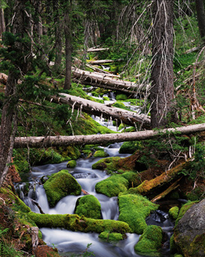
 From
Cascadia, the Byway continues along the South Santiam River. Thick forests
are dominated by Douglas-fir, western hemlock and red cedar; big leaf
maples and red alder provide contrast to the conifers, especially in the
fall. The Byway leaves the river near Mountain House, the most eastern
active homestead on the route; services are available here. Now, the road
begins its climb toward Tombstone Pass (4241 ft elevation), gaining over
2,500 feet in elevation in just seven miles. Several pullouts offer the
chance to glimpse wildlife, and to take in the vistas of Jumpoff Joe,
Green Mountain and Iron Mountain.
From
Cascadia, the Byway continues along the South Santiam River. Thick forests
are dominated by Douglas-fir, western hemlock and red cedar; big leaf
maples and red alder provide contrast to the conifers, especially in the
fall. The Byway leaves the river near Mountain House, the most eastern
active homestead on the route; services are available here. Now, the road
begins its climb toward Tombstone Pass (4241 ft elevation), gaining over
2,500 feet in elevation in just seven miles. Several pullouts offer the
chance to glimpse wildlife, and to take in the vistas of Jumpoff Joe,
Green Mountain and Iron Mountain.
D. Historic Santiam Wagon Road
Much of the Byway parallels the Santiam Wagon Road. Unlike most routes across the Cascades, this road was built to lead settlers away from the Willamette Valley to pasture lands in central Oregon, and to gold mines in eastern Oregon and Idaho. The wagon route was part of the first transcontinental auto race in 1905, when two cars left New York City for Portland, Oregon (the winner made it in 40 days!) Parts of the wagon road are open to pre-1940 vintage vehicles looking to relive a slower pace of travel.
E. Great Old Growth
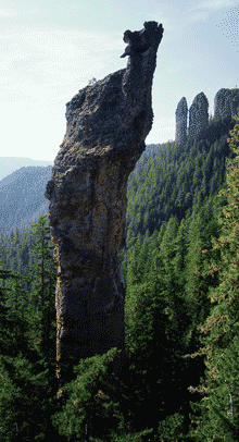
The last segment of the Byway offers some wonderful natural treats. On the grounds of Walton Ranch, a herd of elk tend to congregate in the winter months; platforms are available for viewing. A bit further east is the Menagerie Wilderness area, which offers an impressive collection of rock spires, and is a popular testing ground for rock climbers. Near the end of the Byway you'll reach the Hackleman Old Growth Trail. Two easy-to-walk trails take you through a stand of old growth Douglas fir, western red cedar, and mountain hemlock. Some trees are more than 500 years old! At the junction of Route 20 and Route 126, you can opt for the McKenzie-Santiam Pass or the West Cascades National Scenic Byways.