Historic Columbia River Highway Scenic Byway
Anyway you look at it, the Historic Columbia River Highway Scenic Byway is a marvel — for its visionary engineering, incredible scenery, and rich history. Internationally lauded for spectacular waterfalls, architectural gems, and magnificent overlooks of the Columbia River Gorge, it's no wonder this Byway has been called "King of Roads."
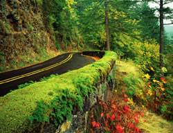
Construction of the Columbia River Highway in 1913 was considered one of the greatest engineering feats of the modern age. Its engineer, Samuel C. Lancaster, did "not [want] to mar what God had put there," and worked diligently to showcase the many waterfalls and other "beauty spots" on the highway's route through the Columbia Gorge. There are numerous historic landmarks along the highway. In fact, the Columbia River Highway is the first scenic highway in the U.S. to be named a National Historic Landmark.
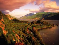
Samuel Lancaster certainly had a magnificent palette to work with. The Columbia River Gorge is 80 miles long and up to 4,000 feet deep, cutting the only sea-level route through the Cascade Mountain Range. Lava flows created the substrate and the Missoula Floods cut through this substrate much later to create the towering cliffs of columnar basalt that make up the Gorge. The Gorge includes 16 endemic plant species (those that exist only within the Gorge) and over 150 rare plant species, and is rich with animal life. The Historic Columbia River Scenic Byway offers ever-shifting perspectives of the Gorge, including sweeping panoramas from 900 feet above the river. Hikers will delight in the many trails along the Byway, some of which lead to hidden waterfalls.
As its name implies, the Byway is incredibly rich in cultural history. This stretch of the Columbia once served as fishing and meeting grounds for the many indigenous peoples of the Columbia Basin. The Dalles was a highly significant trading and rendezvous site throughout history and prehistory. Lewis and Clark's Corps of Discovery followed the river toward its terminus near Astoria in 1805, as did Oregon Trail Pioneers in the mid 1800s. The region's rich history is preserved in several museums along the route.
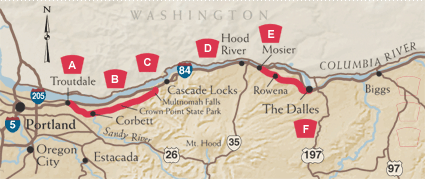
A. Troutdale and the Sandy
 To begin your journey from Portland, take I-84 east to exit 17. Follow the signs through the quaint town of Troutdale and over the Sandy River to the Historic Columbia River Highway. In 1805, Lewis and Clark camped along the banks of the Sandy, which ran gritty with ash from the 1802 eruption of volcanic Mount Hood. The road follows the Wild and Scenic Sandy River for several miles, then climbs past orchards and blueberry fields through the communities of Springdale and Corbett, offering glimpses of snow-capped Mount Hood.
B. Gorgeous Vistas from Crown Point
At the Portland Women's Forum State Park at Chanticleer Point, you get your first glance of the Columbia River and the Gorge: the site of the Chanticleer Inn, and the vista that inspired the Highway's founding father, Sam Hill. The stone guard walls and graceful arches are typical of the highway's exquisite craftsmanship. The Vista House at Crown Point is an Oregon treasure, one of the most photographed and recognizable sites in the Columbia River Gorge. Built as a memorial to Oregon pioneers, it offers an inspiring view of the Gorge and the mountains of the Cascade Range.
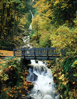
C. Unforgettable Falls
 To
help motorists navigate the 600 foot vertical drop from Crown Point, Lancaster
engineered a series of "figure-eight loops" that gracefully
wind down toward the river. You're soon surrounded by mossy tree limbs,
the greenery enhanced by a series of remarkable waterfalls in the next
five miles: Latourell, Shepperd's Dell, Bridal Veil, and Wahkeena. Soon
you'll reach the granddaddy of Columbia Gorge waterfalls —620 foot
Multnomah Falls. Only three waterfalls in the nation are taller —
and none are more beautiful. A trail from Multnomah Falls Lodge (built
in 1925 and listed in the National Register of Historic Places) takes
you to the lower cascade, then zig zags to the top. A little further down
the road, Horsetail Falls plummets close enough to the road to mist your
windows. Before the Byway joins I-84, at the village of Dodson, you'll
pass Oneonta Gorge, a botanical paradise with more than fifty species
of plants that flourish in the damp, cool environs.
To
help motorists navigate the 600 foot vertical drop from Crown Point, Lancaster
engineered a series of "figure-eight loops" that gracefully
wind down toward the river. You're soon surrounded by mossy tree limbs,
the greenery enhanced by a series of remarkable waterfalls in the next
five miles: Latourell, Shepperd's Dell, Bridal Veil, and Wahkeena. Soon
you'll reach the granddaddy of Columbia Gorge waterfalls —620 foot
Multnomah Falls. Only three waterfalls in the nation are taller —
and none are more beautiful. A trail from Multnomah Falls Lodge (built
in 1925 and listed in the National Register of Historic Places) takes
you to the lower cascade, then zig zags to the top. A little further down
the road, Horsetail Falls plummets close enough to the road to mist your
windows. Before the Byway joins I-84, at the village of Dodson, you'll
pass Oneonta Gorge, a botanical paradise with more than fifty species
of plants that flourish in the damp, cool environs.
D. Bonneville Dam to Hood River
For the next 25 miles, you'll leave the Historic Highway for modern - yet still beautiful - Interstate 84. The Gorge's dramatic geologic formation are a highlight of this segment. Engineering and fishing buffs will want to visit the Bonneville Dam, the first structure to restrain the mighty Columbia. In nearby Cascade Locks, travelers can leave the car for a sternwheeler cruise of the Columbia. More intrepid water sports enthusiasts will want to take to the Columbia at Hood River. Here, the Gorge acts as a wind tunnel to create consistent breezes that have made this once sleepy orchard town the unofficial windsurfing capital of the world. If you're more inclined to stay close to land, be sure to visit the stately Columbia Gorge Hotel (north of I-84 at exit 62), which is listed in the National Register of Historic Places.
E. From Mosier to the Rowena Community
In the 12 miles from Hood River to Mosier, you'll notice a dramatic change in the scenery. It's here that the "two Oregons" meet. As you reach Mosier and the second leg of the Historic Columbia River Highway (off exit 76), the moist and lush western Gorge gives way to dry, eastern Columbia River plateau. Once a booming trade center, Mosier is still famous for its springtime blossoms, fat juicy cherries, and the community's unrivaled passion for native plants. Elegant Mayerdale estate appears unexpectedly on this rural stretch of the road. Look for Memaloose Island in the Columbia, a traditional burial site of Native American peoples of the Columbia Basin that was flooded following the construction of Bonneville Dam. Just west of Mosier, you can walk the Historic Columbia River Highway State Trail through the restored Mosier Twin Tunnels. Farther east, be sure to linger at the viewpoint at Rowena Crest, which affords sweeping Gorge views rivaling those of Crown Point and access to the wildflower wonders of Tom McCall Preserve.
F. The Dalles
The Historic Columbia River Highway spans the extremes of Oregon's landscape, from the damp and mossy western beginning along the banks of the Sandy River to the dry oak savannahs skirting Chenoweth Creek near the historic Dalles. The Dalles was long a Native American gathering place and is rich in Oregon Trail lore. Before you leave the Historic Highway as you enter The Dalles, you'll find the Columbia Gorge Discovery Center and Wasco County Historical Museum. Built as the interpretive center for the National Scenic Area, the Discovery Center has answers to all your questions about the Gorge's history. At the Museum, you'll learn about the earliest inhabitants and hear tales of the traders and settlers who came later. As your tour over the Historic Columbia River Highway comes to a close, consider beginning a new journey to the Lewis and Clark campsite at Rock Fort.
"On starting the surveys, our first business was to find the beauty spots, or those points where the most beautiful things along the line might be seen in the best advantage, and if possible to locate the road in such a way as to reach them." - Samuel C. Lancaster, Historic Columbia River Highway Engineer, 1913
Lewis and Clark Trail
In 1805, and again in 1806, the Corps of Discovery traveled through the Columbia River Gorge. Several important sites mentioned in the journals of Lewis and Clark can still be seen in this area. A historic marker located at Lewis and Clark State Park describes the naming of the Sandy River as the "quicksand" river. Additional markers are located at Rooster Rock, Cascade Locks and Rock Fort in The Dalles.
Bonneville Dam
A little more than ten years after the Historic Columbia River Highway was finished, the face of the Gorge began to change dramatically. Bonneville Dam was started in 1933 and when it was completed, it raised the water level significantly. While the Northwest gained a powerful supply of electricity and flood control, it lost significant historic and prehistoric resources — most notably traditional Native American fishing sites that were so critical to their culture. The loss of these important cultural sites — and the depleted salmon stocks -- has had a lasting impact on the Native American communities. The interpretive center that may be accessed from exit 40 on Interstate 84 highlights the history of the dam, and the fish ladder. Depending on the time of year you visit, you can watch salmon, steelhead sturgeon and other species from the dam's fish viewing station. Best times for viewing are spring and fall.